
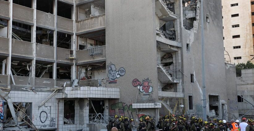
After two rounds of war with Iran exposed critical gaps in how rescue teams accessed structural information at missile‑strike sites, Israeli researchers have developed an artificial intelligence system designed to give first responders near‑instant building data. This capability could sharply reduce the time needed to reach survivors trapped under collapsed homes.
The chaos of war, of buildings collapsed by Iranian ballistic missile fire, underscored how little real‑time structural information was available to rescue units on the ground, prompting researchers to accelerate work they had already begun on Israel’s archive of architectural records.
The project was developed by researchers from the Technion’s Housing Lab, including Prof. Yael Allweil, Dr. Yiftach Ashkenazi, and architect Tal Sadeh, in collaboration with Prof. Moshe Lavee and Liat Bonen from the Elijah Lab at the University of Haifa.
Speaking to The Jerusalem Post, Allweil, a professor of architecture at the Technion, said her team had spent years reviewing building permits, master plans, and other large urban datasets, only for the war to suddenly make their expertise indispensable.
“It was a surprise for us, as historians, to be relevant right now,” she said.
Allweil said the project by the Technion–Israel Institute of Technology and the University of Haifa took on new urgency during Operation Roaring Lion, when colleagues abroad asked how to locate survivors in damaged buildings and how to understand structural layouts quickly enough to assist rescue teams.
Thousands of missiles were fired by Iran during both Operation Rising Lion in June 2025 and Operation Roaring Lion in March 2026. According to the Tax Authority, 39,715 claims were filed after Operation Rising Lion in June 2025 regarding homes being struck by Iranian missiles. Until now, it has taken emergency teams, who rely on printed building permits stored in municipal archives, at least 30 minutes to safely enter a building.
“Each city has an emergency war room, and whenever a building was hit, people would print out the building permit and send it by courier to get it to the location for first responders,” she said. “The first responders needed those printouts before they could even go in, and that took around 30 minutes. Why not know within 30 seconds and be able to assess the situation quicker, especially if there’s more than one site?”
Recognizing the challenge, Allweil and her team began building a new dataset using tools they developed to read complex, rigid building information. They then used AI systems capable of interrogating that data.
“We knew what to ask, to what it could be applied,” she said.
With the IDF’s Home Front Command and municipalities often holding different sets of information, the system was “chaotic,” Allweil said.
The new platform is a web‑based application accessible via a link and built entirely from public data. It allows rescuers to view a building map, see whether apartments contain shelters, and examine individual plans with key structural details. The system can operate in any language and is designed for use in disaster situations worldwide.
“Knowing the basics about the building is extremely important to first responders,” Allweil said.
The tool was developed during the last war and is now being tested with the Nahariya Municipality, where the city engineer is helping verify the platform.
“Buildings in Nahariya are hit constantly,” Allweil told the Post. Despite a ceasefire with Iran currently holding, the goal is to refine the system and expand its use to additional cities.
“Saving lives makes me super motivated,” she said.