
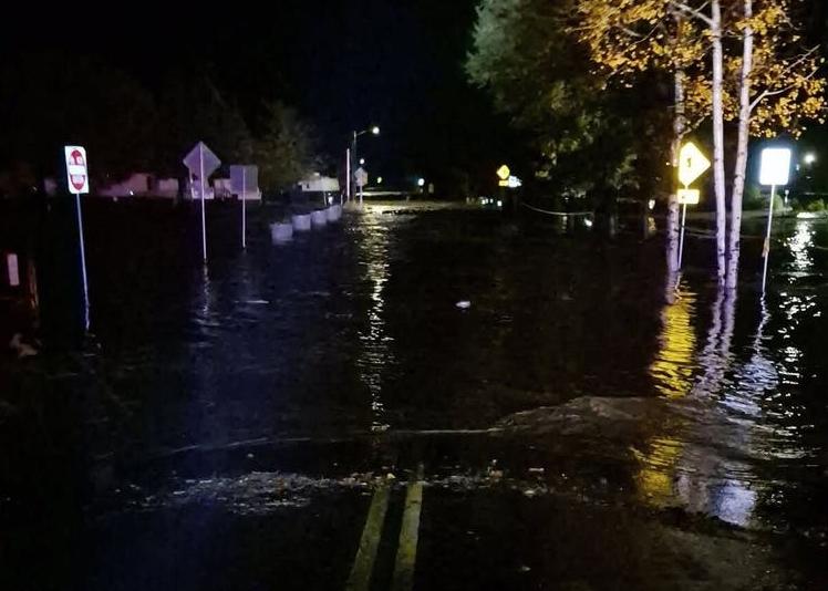
Town of Pagosa Springs / Facebook / FOX Weather (Oct. 23; crop).
Mandatory evacuations are underway in parts of the West as rising rivers and major flooding threaten communities, with an El Niño-fueled storm expected to bring additional impacts to California and the Southwest before sweeping across the country. The powerful system could bring heavy rain, severe thunderstorms and high-elevation snow to parts of 35 states through next week.
KNOW YOUR FLOOD TERMINOLOGY: WHAT FLOOD WATCHES, WARNINGS AND EMERGENCIES REALLY MEAN
Much of the Southwest is bracing for a major flood event, with peak impacts expected to begin today and continue into early Monday. The National Weather Service office in Pueblo, Colorado, is urging residents to complete flood and snow preparations before conditions worsen.
Meanwhile, the entire Central U.S. could see rain, with severe thunderstorms across parts of the South on Election Day.
Portions of Sedona, Arizona, are being urged to evacuate as Oak Creek rapidly rises. Click here to see what areas are under mandatory evacuations.
Southwest Colorado is expected to get drenched with rain once again near the San Juan Mountains. Mandatory evacuations were issued for homes and properties in Pagosa Springs on Saturday, according to town officials.
The FOX Forecast Center said the San Juan River at Pagosa Springs is set to surpass its all-time record of 17.8 feet, potentially cresting as high as 19.71 feet.
A Potentially Dangerous Situation (PDS) River Flood Warning is in effect for the area, with significant and historic flooding possible, according to the National Weather Service (NWS).
Intense thunderstorms brought flash flooding across southern Nevada and the Phoenix metro area on Friday.
Las Vegas was slammed with evening thunderstorms that produced quarter-sized hail, while floodwaters overtopped part of the Lake Mead Highway in Henderson, Nevada.
HOW FLOODWATER CAN MAKE YOU VERY SICK
Meanwhile, intense thunderstorms triggered flash flooding that prompted swift water rescues in Phoenix. No one was injured.
On Halloween, a powerful storm with rich Pacific moisture surged into California and parts of the Southwest.
Southern California experienced moderate-to-heavy soaking rains on Saturday, disrupting Halloween plans, especially for those in larger cities like Los Angeles and San Diego.
FLORIDA MANATEE LEFT STRANDED AS EXTREME LOW TIDE REVEALS HIDDEN DANGER OF KING TIDES
A major flood event is expected across the Southwest from now through early Monday, with dangerous flash flooding and moderate to major river flooding threatening areas already hit by recent flooding, particularly around the Four Corners and Colorado’s San Luis Valley.
A Level 3 out of 4 flash flood risk has been issued for more than 65,000 square miles — roughly the size of Washington — including nearly all of central and northern Arizona and impacting more than four million people.
NOAA’s Weather Prediction Center (WPC) called the system “a high-impact heavy rainfall event” with numerous rivers now forecast to flood and rise to levels close to what they were last week.
Last week’s flash flooding also killed two people in New Mexico as some rivers across the Southwest reached their highest levels in 50 to 100 years.
Up to 5 inches of rain could fall from Phoenix to Flagstaff through Monday. Flagstaff has already recorded 5.69 inches of rain in October.
A foot or more of snow expected to paralyze Colorado’s San Juan mountains
Sunday’s Level 3 threat also includes Pagosa Springs, Colorado, which had to declare a local emergency due to flash flooding last weekend.
“Folks, the window for flood preparations is closing,” the NWS office in Pueblo warned Saturday.
Meanwhile, up in the higher elevations, cold air will become trapped, leading to snow from the Sierra to the Rockies.
COULD SUPER EL NIÑO INFLUENCE THE POLAR VORTEX TO DO SOMETHING IT’S NEVER DONE BEFORE THIS WINTER?
Colorado’s San Juan mountains will see the highest snow totals, between 12 and 18 inches.
“This will likely cause travel impacts along the southwestern mountain roadways, with dangerous and slick road conditions, especially Sunday night into Monday morning,” the NWS said.
Storms move into the Plains and Midwest for Election Day
Later Monday, the storm will begin to move into the Plains and Midwest.
Heavy rain could also increase the risk of flash flooding across the Plains.
Nearly 40 million Americans are under a large Level 1 out of 4 flash flood threat from Texas to Wisconsin on Monday.
Ahead of the storm, a new area of low pressure across the Plains will likely form, allowing warm, moist air to stream in.
That warm air will interact with an approaching cold front, which may allow severe storms to develop along it from Monday into Wednesday, the FOX Forecast Center said.
“Right now, a limiting factor is how much instability or storm energy will set up in the region,” the FOX Forecast Center said.
“Still, the atmosphere is becoming primed and energized for severe storms to develop from Texas into parts of the Southeast.”
Currently, a Level 2 out of 5 risk of severe thunderstorms covers Kansas, Oklahoma and northern Texas, including Oklahoma City and Wichita.
Any severe storms would develop in the afternoon, producing mainly damaging wind gusts and a couple of tornadoes.
WATCH: SANTA FE ROCKED BY FIRST TORNADO IN 50 YEARS AS RARE TWISTER LEAVES BEHIND WIDESPREAD DAMAGE
Forecast uncertain for late week
From Wednesday onward, the storms will continue moving into the East, potentially bringing heavy rain Thursday and Friday to major cities on the I-95 corridor.
Locations from Raleigh, North Carolina, to Washington, D.C., New York City and Boston could all see rain for the first time in nearly two weeks.
This could be just a small preview of a dangerous, El Niño-driven wet pattern this winter, with a Super El Niño expected to be declared later this year.
El Niño generally brings a stormy winter pattern to California and the Southern Tier of the country by nudging the Pacific jet stream southward. The jet stream acts as an atmospheric conveyor belt for storms.
Originally published by FOX Weather.
JBizNews Desk | New York
© JBizNews.com. All rights reserved. Unauthorized reproduction or redistribution is strictly prohibited.