
New Yorkers are being invited to weigh in on the city’s plans to create more than 40 miles of greenways across the outer boroughs. Department of Transportation (DOT) Commissioner Mike Flynn on Monday announced that the planning process for four greenways in the Bronx, Brooklyn, Staten Island, and southern Queens will begin this fall. Residents interested in shaping the projects can attend a series of workshops. The first workshop, focused on the Bronx greenway, is slated for November 4.
“Greenways connect New Yorkers to parks, jobs, and other major neighborhood destinations with safe paths to walk, run, or bike,” Flynn said. “We’re excited to conduct a community-driven planning process so New Yorkers can share their vision for generational public space upgrades in their neighborhoods.”
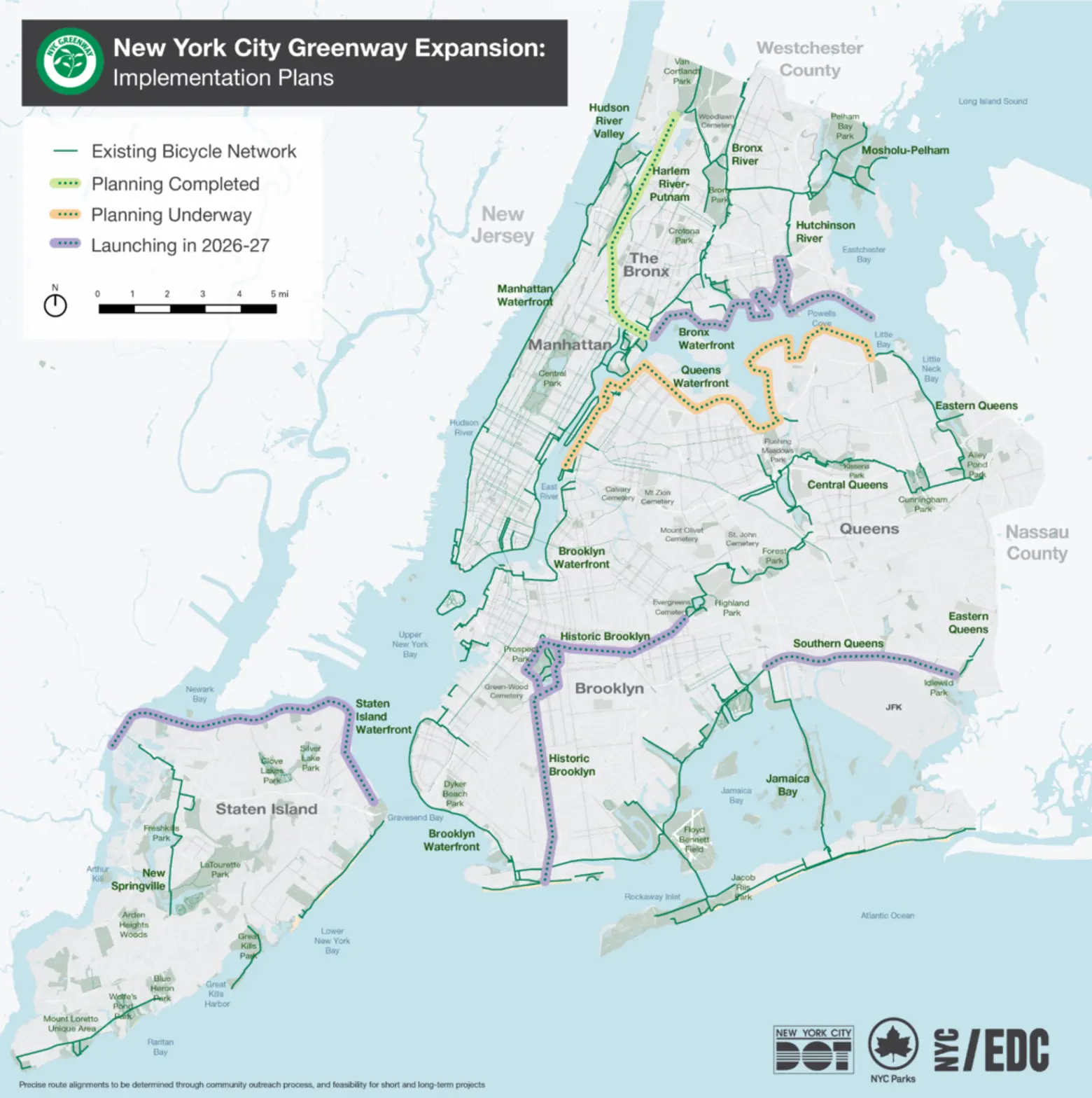
The Bronx greenway proposal includes a 15-mile route running east from Randall’s Island to SUNY Maritime, designed to improve commutes to industrial job centers like Hunts Point and better connect waterfront parks in the Soundview and Throggs Neck neighborhoods.
The first round of in-person and virtual workshops for the project will gather public feedback on existing conditions, along with residents’ suggestions, concerns, and ideas for the greenway.
An in-person workshop is scheduled for Wednesday, November 4, from 6 p.m. to 8 p.m. at the BankNote Building at 1231 Lafayette Avenue in Hunts Point. A virtual session will follow on Thursday, December 3, from 6 p.m. to 8 p.m. Residents can register for either or both workshops here.
Workshops for the remaining greenway corridors in Brooklyn, Queens, and Staten Island are expected to begin in 2027.
In Brooklyn, the planning process will explore new connections to the country’s oldest bike lanes along Ocean and Eastern Parkways, addressing a 12-mile gap in the existing greenway network between Coney Island and Highland Park, near the Brooklyn-Queens border.
The proposed route would also connect to Broadway Junction, one of the borough’s busiest transit hubs, giving commuters new cycling routes to major green spaces such as Prospect Park.
In southern Queens, the proposed 7-mile greenway would improve cycling access to John F. Kennedy International Airport, complementing the Port Authority’s ongoing efforts to simplify the roadway network surrounding the airport.
The corridor would bring new cycling infrastructure to an area with few existing bike routes while connecting directly to the Jamaica Bay Greenway and parks in southeast Queens, expanding the area’s network of cycling routes.
On Staten Island, a proposed 10-mile greenway stretching from the Goethals Bridge to the Verrazzano Bridge would create an east-west route for cyclists and pedestrians across the North Shore, connecting to projects such as the Tompkinsville Esplanade and the New Stapleton Waterfront. The route would also link to destinations including the St. George Ferry Terminal and the East Shore beachfront.
DOT, NYC Parks, and the Economic Development Corporation are working together to develop implementation plans for each project. DOT will identify and carry out short-term improvements along each route while continuing to plan the new greenways.
Short-term work may include pavement markings, signage, and concrete improvements on city streets, while longer-term plans call for more substantial, permanent upgrades funded through future capital investments.
These plans build upon the “Greater Greenways” plan, released by the city in 2025. The plan called for an assessment of the city’s existing 500-mile bike network and 40 miles of new greenways to fill gaps across the five boroughs.
RELATED:
- Battery Bikeway reopens with completion of $221M flood-resiliency project
- After street redesign, 5.5-mile protected bike corridor between Sunset Park and Dumbo is complete
- NYC releases greenway master plan with 40 miles of new paths
The post NYC wants your input on plans to create 40 miles of greenways in the outer boroughs first appeared on 6sqft.