
Experts have unlocked secrets hidden for two centuries in a chart made for Indian Ocean seafarers, shedding new light on an indigenous system of navigation in the Red Sea and Gulf of Aden that predates more modern instrument-based methods.
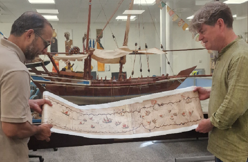
The Kachchhi/Gujarati chart, one of the most detailed surviving indigenous navigational charts from the Indian Ocean tradition, has been part of the Royal Geographical Society’s collection for 189 years.
The document, dated to the late 18th or early 19th century, is illustrated with images of ships and religious buildings. It depicts more than 180 islands, along with reefs, landmarks and flags.
Of the 180, 66 are written in Devanagari, the alphabet used for Sanskrit, Hindi, and other Indian languages – and before today, have never been properly identified.
The chart was acquired in 1835 by Alexander Burnes, a lieutenant in the East India Company service and assistant to the British Resident in Kachchh, who obtained it from an unnamed sea captain before donating it to the Royal Geographical Society.
Identifying 66 locations for first time
The chart was subsequently examined by scholars in 1947, 1987, 2002, 2012 and 2022, yet its navigational function remained largely overlooked throughout. Roughly half of its Devanagari names were left unidentified or unlocated, with even more lacking precise coordinates.
However, researchers from the University of Exeter have for the first time, been able to identify the names of places and astronomical data inscribed on the chart, establishing latitude readings and sailing directions that demonstrate a far more sophisticated document than previously understood.
Using this new data, researchers have been able to create a projection of the chart that presents the information spatially, similar in fashion to modern maps.
Coordinates for all 66 previously unidentified locations on the chart have been established, said the researchers, who have successfully produced improved transcriptions of the Devanagari script.
The study also determined that the chart’s 29 rhumb lines served three distinct navigational purposes: establishing the principal trend of a coastline, indicating a direction of travel across open water, and, in at least two instances, marking safe passage into and out of port.
Professor John Cooper of the University of Exeter’s Institute of Arab and Islamic Studies, who led the research, said the chart reflected a navigational tradition fundamentally different from modern cartography.
“Today we are used to maps and charts that project space mathematically and to scale, making regions of the world visually familiar and accessible to us in a very particular way,” Cooper said. “Although this chart doesn’t look accurate to our way of thinking, it allowed seafarers with the necessary experience and knowledge of stellar navigation to negotiate some of the harshest and most challenging waters in the world.”
“All the required information was packed into a very portable scroll just 25 centimeters wide.”
“This is a rich and effective navigational reference work,” he added, noting that the chart’s various elements each carried practical significance. “Its stellar information allowed sailors to know their latitude and set sailing directions.”
“Its many place names and topographical information enabled them to locate themselves precisely; its religious buildings suggest the navigator’s Muslim faith; and its flags suggest nodes of political and fiscal action.”
Not only for general navigational use
Further, Cooper noted that the chart was not designed for general use but for those with “specific local navigational knowledge.”
“Although rich, the inscribed information would not be enough to enable people uninitiated in regional seafaring traditions to navigate safely,” he said. “But for those who knew, it functioned as a handy reference at sea, fulfilling a mnemonic role. Its scroll format allowed it to be opened partially, showing only the relevant section, with the rest rolled away. It stored and handled easily on board ship.”
Dr. Katherine Parker, the Royal Geographical Society’s Cartographic Collections Manager, said that the findings underscore the value of revisiting historical records and artifacts armed with contemporary tools.
“Re-examining our collections is an ongoing process that allows researchers to apply new methods, technologies and perspectives, uncovering the meanings and utility that these remarkable artefacts held for the people who created them centuries ago,” Parker said. “We have been delighted to work alongside the team to bring a greater understanding of the navigational, geographical and cultural value of this chart, as well as the cartographic skill and knowledge of its creators, into focus.”